As early as 1853, biodiesel has been made from used vegetable oil. Nowadays, engineers have figured out how to use biodiesel to power cars and even airplanes. By chemically reacting lipids with an alcohol, anyone can make their own biodiesel. Many fast food restaurants that use oil to fry their food are willing to give away the used oil. Because restaurants have to pay to get rid of the used oil, it is easy for anyone to get a hold of large amounts of oil. After a process called transesterification, you are left with a layer of biodiesel and a layer of glycerin. This glycerin can be used to make a variety of soaps and candles while the biodiesel can be used for fuel. Hooray for economically friendly biproducts! Below is a link to a Youtube video where you can learn how to make your own biodiesel.
http://www.youtube.com/watch?v=ramY_M_z4pk
Wednesday, November 20, 2013
Monday, November 4, 2013
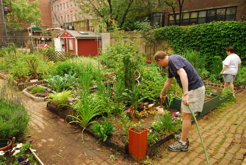
Community Gardens
A garden is an extremely important part to the success of a community. Not only are these gardens used to grow vegetables and herbs, they are also a place of communication. People can come to the community gardens to socialize and get to know others within the city or town. The garden provides people will a common topic to talk about. Normally, these gardens are also beautiful. Having a section of the city dedicated to green, vegetable producing plants, increases the beauty of the city. The vegetables produced at these gardens is much healthier than any that could be bought at a store. Growing your own food ensures the best quality produce possible. The best part of having a community garden is the positive effect it has on the environment. Plants take carbon dioxide that humans exhale, and through photosynthesis, transform it into oxygen. Community gardens create an abundance of fresh oxygen that we get to breathe. I think this trend will continue to grow throughout the United States. Soon every town will have a garden that anyone can be a part of and make a difference.
12 Soils of the World-and Georiga
If you were to ask a common person about how many types of soil there are in the world, most would say only a few. However, there are 12 major soil types throughout our planet. The following link will bring to you to a website that maps out each type of soil and its properties. The following diagram is a map of the 12 soil types around the world and how they are dispersed.
http://www.cals.uidaho.edu/soilorders/

The soil type of Georgia is mainly ultisols, a redish clay soil. The red comes from oxidized iron in the soil. Because of the amount of iron in the soil, it is hard to grow certain plants. This type of soil is also known to stain clothing and cover cars that drive on it.
A micaceous schist is simply a schist rock with more mica. This rock is metamorphic which means it was transformed by extreme pressure and heat to create a new rock. The mica makes the rock especially sparkly and seem like it has glitter in it. The picture below is what a micaceous schist looks like.

Thursday, October 17, 2013
Tree Identification
Today in lab, we walked around campus and identified many different types of trees and bushes. Although it was quite hot, we were able to see a bunch of different species of plants. Here are 3 of the types that we saw throughout campus.
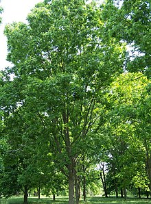 This is a pecan tree. They are native to South Central America. Pecan trees go to be anywhere from 20 - 40 meters tall. We learned that you can eat the pecans straight from the tree when they are ripe. "Pecan" means nut requiring a stone to crack in Algonquian.
 This is a crepe myrtle also known as Lagerstroemia. This tree is not native to America, although it is commonly grown here in parks and suburban areas. It sprouts bright pink or white flowers in the summer and can grow to be up to 100 feet tall.
 This is common holly. Holly is a genus of 400 to 600 species. They are evergreen and grow pretty much everywhere in the world. The small berries on holly are slightly toxic to humans and can make someone sick if they ate any.
This is a pecan tree. They are native to South Central America. Pecan trees go to be anywhere from 20 - 40 meters tall. We learned that you can eat the pecans straight from the tree when they are ripe. "Pecan" means nut requiring a stone to crack in Algonquian.This is a crepe myrtle also known as Lagerstroemia. This tree is not native to America, although it is commonly grown here in parks and suburban areas. It sprouts bright pink or white flowers in the summer and can grow to be up to 100 feet tall.This is common holly. Holly is a genus of 400 to 600 species. They are evergreen and grow pretty much everywhere in the world. The small berries on holly are slightly toxic to humans and can make someone sick if they ate any.
Tuesday, September 24, 2013
Ocmulgee River Lab
Parks are an important aspect to a city. They create a sense
of community that is unmatched by anything else. They allow people, no matter
their social class, a place to relax and associate with others within the city.
Parks are also one of the last places that people can go to be with nature.
Ocmulgee Heritage Trail is where we conducted our research.
With over 1,500 acres of green space, Ocmulgee is almost double the size of
Central Park in New York. We measured the elevation profile of the river along
with the flow rates of two channels (one on each side of the sandbar).

The green line is where we measured the elevation changes under the water. The sandbar above the line is where we measured the flow rate of the water running through the river.
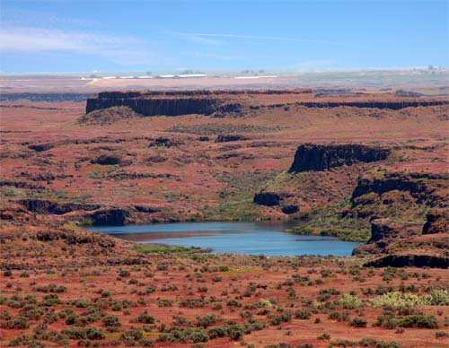
Mystery of the Mega Flood
For hundreds of years, geologists were confused on how the Channeled Scablands were created. At first, they thought a huge river that had once existed, created the Scablands. This idea, however, was shot down by the fact that there are giant pothole formations that could not have been created by a river. Erratics, large granite rocks, are randomly placed around the Scablands as well, negating the possibility of a river making such a landscape. Finally, geologists were able to come to a conclusion. By observing large ripples left on the floor of the Scablands, they were able to conclude that a giant flood had to create the diverse landscape. They discoverd that Glacial Lake Missoula, located in Montana, had to have burst. A glacier at the front of the lake created a plug, stopping the lake from overflowing, until it could not hold anymore. Super-cooled water ran through the cracked glacier and caused all the lake water to rush towards the Pacific, creating the Channeled Scablands.
Tuesday, September 10, 2013
Topographic Map of Morgan Hill, CA
This is a topographic map of Morgan Hill. I measured the elevation of the west hills of town that get the most rainfall, seeing that it is the closest to the Pacific Ocean.
 The red line represents an elevation of 1,100ft. The orange line represents an elevation of 1,000ft. The yellow line represents an elevation of 900ft. The green line represents an elevation of 800ft. The blue line represents an elevation of 700ft. The purple line represents an elevation of 600ft.

Subscribe to:
Comments (Atom)